
APULICA / WALKS
Way of St Thomas
Rome, St Peter's Basilica → Ortona, Cathedral of St Thomas the Apostle · italia.it and the official site give 316 km. Other pages of the same official site speak of about 310 km and of the 313 km of its adopt-a-kilometre project. By mountain bike the recommended route measures 372 km. · 16 stages, one a day, according to italia.it and the official site; italia.it gives stages of about 25 km on flatter sections and about 15 km on those with more climbing. By mountain bike there are 7 recommended stages.
Key facts
| Start and finish | Rome, St Peter's Basilica → Ortona, Cathedral of St Thomas the Apostle |
|---|---|
| Length | italia.it and the official site give 316 km. Other pages of the same official site speak of about 310 km and of the 313 km of its adopt-a-kilometre project. By mountain bike the recommended route measures 372 km. (Il Cammino di S. Tommaso lungo la costa adriatica - italia.it (Ministero del Turismo) · Cammino di San Tommaso - Il progetto · Cammino di San Tommaso - Mettiti in cammino (Carta del Pellegrino) · Cammino di San Tommaso - Il simbolo del Cammino · Cammino di San Tommaso - Adotta il Cammino · Cammino di San Tommaso - Cammino in MTB) |
| Stages | 16 stages, one a day, according to italia.it and the official site; italia.it gives stages of about 25 km on flatter sections and about 15 km on those with more climbing. By mountain bike there are 7 recommended stages. (Il Cammino di S. Tommaso lungo la costa adriatica - italia.it (Ministero del Turismo) · Cammino di San Tommaso - Percorso a piedi (tappe) · Cammino di San Tommaso - Cammino in MTB) |
| Credential | The association issues the Carta del Pellegrino (pilgrim card), numbered, stamped and signed, in return for a free donation; it entitles the holder to pilgrim treatment at affiliated lodgings. Those who walk at least the Manoppello - Ortona or Rome - Subiaco section can receive "Il Perdono", the certificate of completion. (Cammino di San Tommaso - Mettiti in cammino (Carta del Pellegrino)) |
| Regions | Abruzzo (The route starts in Rome: according to italia.it the first 100 km or so are in Lazio, and it enters Abruzzo on the ridge of Monte Autore, at Camporotondo di Cappadocia.) |
| Official website | www.camminodisantommaso.org |
Map, stages and elevation
Abruzzo stages mapped on OpenStreetMap: 6 mapped stages, 126 km, 3504 m of ascent and 3772 m of descent computed on the terrain model. Official distances may differ: the figures published by the route prevail.
| Stage | From – to | km | Ascent | Descent | Max altitude |
|---|---|---|---|---|---|
| 11 | Fontecchio – Capestrano | 23.0 | 657 m | 823 m | 1060 m |
| 12 | Capestrano – Pescosansonesco | 15.9 | 665 m | 601 m | 969 m |
| 13 | Pescosansonesco – Manoppello | 26.8 | 417 m | 780 m | 567 m |
| 14 | Manoppello – San Martino sulla Marruccina | 22.3 | 968 m | 613 m | 615 m |
| 15 | San Martino sulla Marruccina – Crecchio | 22.8 | 620 m | 655 m | 442 m |
| 16 | Crecchio – Ortona | 15.7 | 177 m | 300 m | 205 m |
Route: © OpenStreetMap contributors (ODbL) · Elevation: EU-DEM v1.1, Copernicus · Outlines: ISTAT · updated 2026-10-11
In brief
- It links Rome and Ortona across the Apennines, passing through two national parks and four regional parks according to italia.it. (Il Cammino di S. Tommaso lungo la costa adriatica - italia.it (Ministero del Turismo))
- It takes its cue from the journey made in the fourteenth century (between 1365 and 1368) by St Bridget of Sweden, from St Peter's to the tomb of the apostle Thomas in Ortona. (Il Cammino di S. Tommaso lungo la costa adriatica - italia.it (Ministero del Turismo) · Cammino di San Tommaso - Il progetto)
- Its highest point is Monte Autore, at 1,855 m, in the Simbruini mountains. (Il Cammino di S. Tommaso lungo la costa adriatica - italia.it (Ministero del Turismo))
- From Serramonacesca to Ortona the route coincides with the last three stages of the Great Way of Celestine. (Cammino Grande di Celestino (Ente Parco Nazionale della Maiella) - Tappa 10 · Parco Nazionale della Maiella - Gli eremi della Maiella, dall'Aquila a Ortona)
Why walk it
The Way of St Thomas cuts across the peninsula from the Tyrrhenian to the Adriatic and leads through unspoilt country little visited by tourists. From the summit of Monte Autore the view opens in every direction, the path crosses one of Europe's most extensive beech forests and later reaches the Pagliare di Tione, a village of stone huts at the foot of Monte Sirente. In the Capestrano basin the Adriatic comes into view for the first time, and from then on it shows the way.
Spirituality accompanies every day: Subiaco with St Benedict's Sacro Speco, at Bominaco the oratory of San Pellegrino, whose frescoes have earned it comparison with the Sistine Chapel, the Abbey of San Liberatore a Maiella and finally the apostle's tomb in Ortona.
It is designed for slow, experiential travel, in which each walker sets their own pace and chooses where to stop. Along the way you pass villages struck by the 2009 earthquake and restored to their beauty, such as Fontecchio and Capestrano, the saffron country of the PDO Zafferano dell'Aquila at Navelli and, nearer the coast, olives, vines and figs; the association also highlights the food and wine heritage of the route.
Sources: Il Cammino di S. Tommaso lungo la costa adriatica - italia.it (Ministero del Turismo) · Cammino di San Tommaso - sito ufficiale (Associazione Il Cammino di San Tommaso APS) · Cammino di San Tommaso - Il progetto
From Peter to Thomas
Nature, culture and faith intertwine along this route, which runs from St Peter's Basilica in Rome to the Cathedral of St Thomas in Ortona, where the apostle's remains are kept. It crosses the Apennines between Lazio and Abruzzo, taking the old Roman consular road, the Tiburtina Valeria, as its reference line.
According to italia.it it passes through the Gran Sasso and Maiella national parks and the regional parks of the Appia Antica, the Castelli Romani, the Monti Simbruini and Sirente-Velino. It can be done on foot, by bike on road and gravel, and on horseback.
The project was started in 2013 by a group of young hikers from Ortona, who took Santiago de Compostela as their model; the association of the same name continues to look after the route through its technical group.
Sources: Il Cammino di S. Tommaso lungo la costa adriatica - italia.it (Ministero del Turismo) · Cammino di San Tommaso - Il progetto · Cammino di San Tommaso - Percorso a piedi (tappe) · Cammino di San Tommaso - L'associazione · Cammino di San Tommaso - Mettiti in cammino (Carta del Pellegrino)
The sixteen stages
The official site lists these stages: Rome, St Peter's Square - Albano Laziale; Albano Laziale - Artena; Artena - Genazzano; Genazzano - Subiaco; Subiaco - Monte Livata; Monte Livata - Camporotondo; Camporotondo - Tagliacozzo; Tagliacozzo - Massa d'Albe; Massa d'Albe - Rocca di Mezzo; Rocca di Mezzo - Fontecchio; Fontecchio - Capestrano; Capestrano - Pescosansonesco; Pescosansonesco - Manoppello; Manoppello - San Martino sulla Marrucina; San Martino sulla Marrucina - Crecchio; Crecchio - Ortona, Cathedral of St Thomas.
According to italia.it, from Rome the route follows the Appia Antica and, near Marino, the Via Francigena del Sud as far as Lake Albano; then Artena, Genazzano and Subiaco. From Monte Livata it climbs to Monte Autore, with a variant running 100 m lower, and enters Abruzzo at Camporotondo di Cappadocia; then come Tagliacozzo, Massa d'Albe with Alba Fucens, and the Rocche plateau.
After Fontecchio it passes Bominaco and Navelli to Capestrano, then the springs of the Tirino and Pescosansonesco. From Manoppello it descends along the Alento and the Foro valley towards San Martino sulla Marrucina and Crecchio, from where Ortona is 14 km away. From Serramonacesca to Ortona the route coincides with the last three stages of the Great Way of Celestine.
Sources: Il Cammino di S. Tommaso lungo la costa adriatica - italia.it (Ministero del Turismo) · Cammino di San Tommaso - Percorso a piedi (tappe) · Cammino Grande di Celestino (Ente Parco Nazionale della Maiella) - Tappa 10 · Parco Nazionale della Maiella - Gli eremi della Maiella, dall'Aquila a Ortona
Terrain, waymarking and difficulty
italia.it describes it as a route that requires some training and practice. After the Castelli Romani the gradients increase, and from Subiaco the real climbing begins, up to Monte Autore at 1,855 m, the highest point of the route; the following section, descending through beech woods on cart tracks, is easier.
The Abruzzo interior also has demanding climbs and descents: reaching the Rocche plateau, between 1,200 and 1,400 m, involves rough stretches, particularly on the stretch from the Fonte Capo La Marina pass towards Rovere, and between Rocca di Mezzo and Fontecchio there is a detour with 20% gradients.
As for waymarking, the association reports that it installed vertical signs along practically the whole route thanks to its 2019 and 2020 "Adotta il Cammino" campaigns, while noting that work remains to be done; the funds raised also pay for maintaining the trail. Among its packing tips, the site lists trekking shoes or shoes with thick soles and a sleeping bag or mat.
Sources: Il Cammino di S. Tommaso lungo la costa adriatica - italia.it (Ministero del Turismo) · Cammino di San Tommaso - Prima di partire · Cammino di San Tommaso - Adotta il Cammino
Pilgrim card and hospitality
The Carta del Pellegrino certifies the traveller's presence on the route and the association regards it as the pilgrim's identity document, not a discount card. It is requested through the form on the site with a free donation: the association then posts the original card, together with the stage-by-stage guide and the list of affiliated lodgings. Alternatively, everything can be collected by appointment at the Spazio Pellegrino in Ortona. Only the numbered, stamped and signed card gives the right to pilgrim treatment.
Those who complete at least the Manoppello - Ortona or Rome - Subiaco section can receive "Il Perdono", the certificate of the walk: in Ortona at the Spazio Pellegrino, or by post for the Lazio section. According to italia.it the whole route is served by places offering hospitality; the official site does not specify their types and refers walkers to the list of affiliated lodgings supplied with the card.
For those who want to walk only part of the route, italia.it points to Subiaco, Rocca di Mezzo, Tagliacozzo and Manoppello as places well served by public transport and suitable as start or end points.
Sources: Il Cammino di S. Tommaso lungo la costa adriatica - italia.it (Ministero del Turismo) · Cammino di San Tommaso - Mettiti in cammino (Carta del Pellegrino) · Cammino di San Tommaso - Prima di partire
In the footsteps of St Bridget
The relics of the apostle Thomas have been kept in Ortona since 1258, in a gilded sarcophagus in the cathedral crypt. Between 1365 and 1368 St Bridget of Sweden, now a co-patron of Europe, travelled from Rome to Ortona after a revelation about the presence of the saint's bones; according to local tradition she visited the tomb twice, and her passage is remembered by an old church dedicated to her in Arielli and by a stone marker at Porta Caldari in Ortona.
The association Il Cammino di San Tommaso was founded in Ortona in 2013 and introduced the route with a group journey from Ortona to Rome, from 26 May to 9 June 2013: 76 participants, walkers, riders and cyclists, reached Rome for the Angelus, in which Pope Francis greeted the pilgrims from Ortona.
In 2014 and 2015 the event was repeated in the opposite direction, from Peter to Thomas, and for the 2014 edition the pope granted a plenary indulgence to participants. After the last edition in 2016, since September of that year the route has been walked independently.
Sources: Il Cammino di S. Tommaso lungo la costa adriatica - italia.it (Ministero del Turismo) · Cammino di San Tommaso - Il progetto · Cammino di San Tommaso - L'associazione
Places along the route
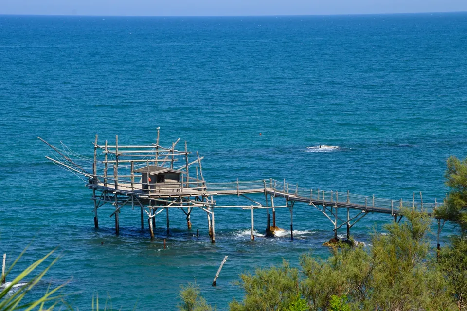
Trabocchi Coast
The Chieti coastline between Ortona and Vasto, with some thirty wooden trabocchi and the hermitage where D’Annunzio stayed.
Read the guide →Photo: Francesca Piersanti / Wikimedia Commons — CC BY-SA 4.0 · Resized and converted to WebP.

Places of faith on the route
Co-Cathedral Basilica of St Thomas the Apostle
Basilica · Ortona (Chieti) · San Tommaso Apostolo
Basilica Shrine of the Holy Face of Manoppello
Sanctuary · Manoppello (Pescara) · Volto Santo, Frati Minori Cappuccini
Sources
- Il Cammino di S. Tommaso lungo la costa adriatica - italia.it (Ministero del Turismo)
- Cammino di San Tommaso - sito ufficiale (Associazione Il Cammino di San Tommaso APS)
- Cammino di San Tommaso - Il progetto
- Cammino di San Tommaso - Percorso a piedi (tappe)
- Cammino di San Tommaso - Cammino in MTB
- Cammino di San Tommaso - L'associazione
- Cammino di San Tommaso - Il simbolo del Cammino
- Cammino di San Tommaso - Mettiti in cammino (Carta del Pellegrino)
- Cammino di San Tommaso - Prima di partire
- Cammino di San Tommaso - Adotta il Cammino
- Cammino Grande di Celestino (Ente Parco Nazionale della Maiella) - Tappa 10
- Parco Nazionale della Maiella - Gli eremi della Maiella, dall'Aquila a Ortona