Why go
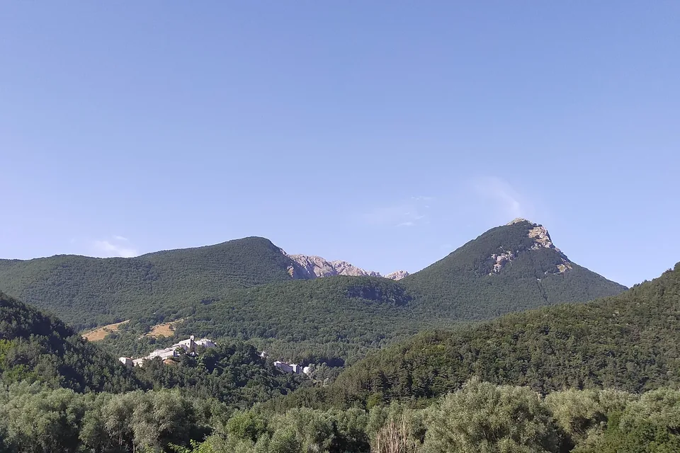
Gran Sasso and Monti della Laga National Park protects the highest part of the Apennines. Corno Grande rises to 2,912 metres, the highest point of the range, and twenty mountains top 2,000 metres along more than fifty kilometres of ridges, broken only by the Capannelle pass at 1,300 metres. The Park Authority’s official map gives an area of 148,935 hectares, which the park’s own history rounds to about 150,000.
Three very different mountain groups meet here. Gran Sasso and the Monti Gemelli are made of limestone and dolomite, with sheer rock faces, glacial cirques and wide plateaux; Monti della Laga are sandstone and marl, rich in water, with streams, waterfalls and forests. The Authority describes the park as a hinge between the Euro-Siberian and Mediterranean regions, and its flora page counts 2,364 recorded species, enough for the Authority to rank it among the European protected areas richest in plants. Alongside this nature come fortified villages, abbeys, pastures and high fields, which make the park a territory lived in for centuries.
The park extends across three regions, five provinces and 44 municipalities. In Abruzzo it includes sixteen municipalities in the province of L’Aquila (Barete, Barisciano, Cagnano Amiterno, Calascio, Campotosto, Capestrano, Capitignano, Carapelle Calvisio, Castel del Monte, Castelvecchio Calvisio, L’Aquila, Montereale, Ofena, Pizzoli, Santo Stefano di Sessanio and Villa Santa Lucia degli Abruzzi), fourteen in the province of Teramo (Arsita, Campli, Castelli, Civitella del Tronto, Cortino, Crognaleto, Fano Adriano, Isola del Gran Sasso d’Italia, Montorio al Vomano, Pietracamela, Rocca Santa Maria, Torricella Sicura, Tossicia and Valle Castellana) and ten in the province of Pescara (Brittoli, Bussi sul Tirino, Carpineto della Nora, Castiglione a Casauria, Civitella Casanova, Corvara, Farindola, Montebello di Bertona, Pescosansonesco and Villa Celiera). In Lazio the park takes in Accumoli and Amatrice, in the province of Rieti; in Marche, Acquasanta Terme and Arquata del Tronto, in the province of Ascoli Piceno. A municipality’s whole territory does not always lie within the protected area.
Sources: Parco Nazionale del Gran Sasso e Monti della Laga — Morfologia · Parco Nazionale del Gran Sasso e Monti della Laga — L’altopiano di Campo Imperatore · Parco Nazionale del Gran Sasso e Monti della Laga — Mappa del Parco · Parco Nazionale del Gran Sasso e Monti della Laga — La storia del Parco · Parco Nazionale del Gran Sasso e Monti della Laga — Il territorio · Parco Nazionale del Gran Sasso e Monti della Laga — Flora e vegetazione · Parco Nazionale del Gran Sasso e Monti della Laga — Borghi e paesi (pagina 1) · Parco Nazionale del Gran Sasso e Monti della Laga — Borghi e paesi (pagina 2) · Parco Nazionale del Gran Sasso e Monti della Laga — Borghi e paesi (pagina 3)
History
The park was born with the framework law on protected areas, Law 394 of 6 December 1991. Drawing its boundaries took years: a ministerial decree of 4 December 1992 set the first provisional perimeter, protection measures and new definitions followed, and the area shrank from the 220,000 hectares first planned to today’s roughly 150,000. The Presidential Decree of 5 June 1995 established the Park Authority and fixed the present perimeter; in 2025 the Authority marked thirty years with a programme of events across the territory.
In 2001 the headquarters moved from the historic centre of L’Aquila to Assergi, into the fourteenth-century former Franciscan convent that the Authority restored with co-funding from Regione Abruzzo. Besides the administrative seat, the Authority has a scientific centre at Farindola, one for cultural heritage at Isola del Gran Sasso and one for food and farming at Amatrice. To plan works and services it divided the park into eleven districts with purely virtual borders, which also name its food itineraries: Terre della Baronia, Alte Vette, Strada Maestra, Valle Siciliana and the others.
The longest story, though, belongs to the shepherds. In summer the pastures of Campo Imperatore receive flocks of sheep and herds of cattle and horses which in winter move down to Puglia, a practice the Authority traces back thousands of years, and its institutional brochure calls Castel del Monte the historic capital of transhumance. Sheepfolds, stone huts and droving tracks can still be read along the trails. The Apennine chamois, the park’s emblem, has a story of return too: it vanished from Gran Sasso and came back through a reintroduction project a hundred years after it had died out there.
Sources: Parco Nazionale del Gran Sasso e Monti della Laga — La storia del Parco · Parco Nazionale del Gran Sasso e Monti della Laga — 30 anni di storia, natura e tradizione · Parco Nazionale del Gran Sasso e Monti della Laga — L’altopiano di Campo Imperatore · Parco Nazionale del Gran Sasso e Monti della Laga — Brochure istituzionale (PDF) · Parco Nazionale del Gran Sasso e Monti della Laga — Itinerari a piedi · Parco Nazionale del Gran Sasso e Monti della Laga — Fauna
What to see
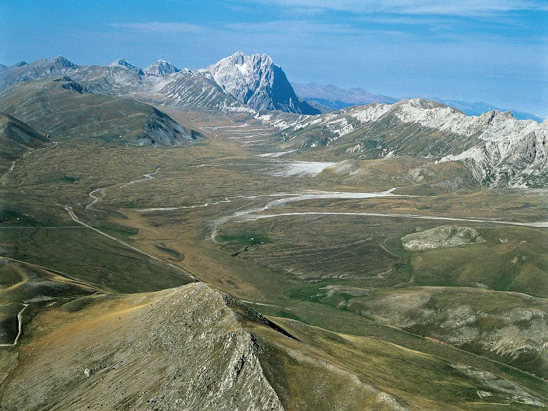
Campo Imperatore is the largest plateau in the Apennines: it lies between 1,500 and 1,900 metres and is about twenty kilometres long and three to seven wide. It is reached from Assergi over the Fossa di Paganica, from Castel del Monte over the Capo la Serra pass or from Farindola over the Vado di Sole. Around it rise Corno Grande with its four summits, Monte Aquila, Brancastello, Monte Prena and Monte Camicia. Moraines, cirques and gravel spreads recall the glacier that until about fifteen thousand years ago ran for eleven kilometres from the Monte Aquila valley to the Coppe di Santo Stefano. The treeless grasslands are home to rare plants and to Orsini’s viper, a small, strictly protected high-mountain snake.
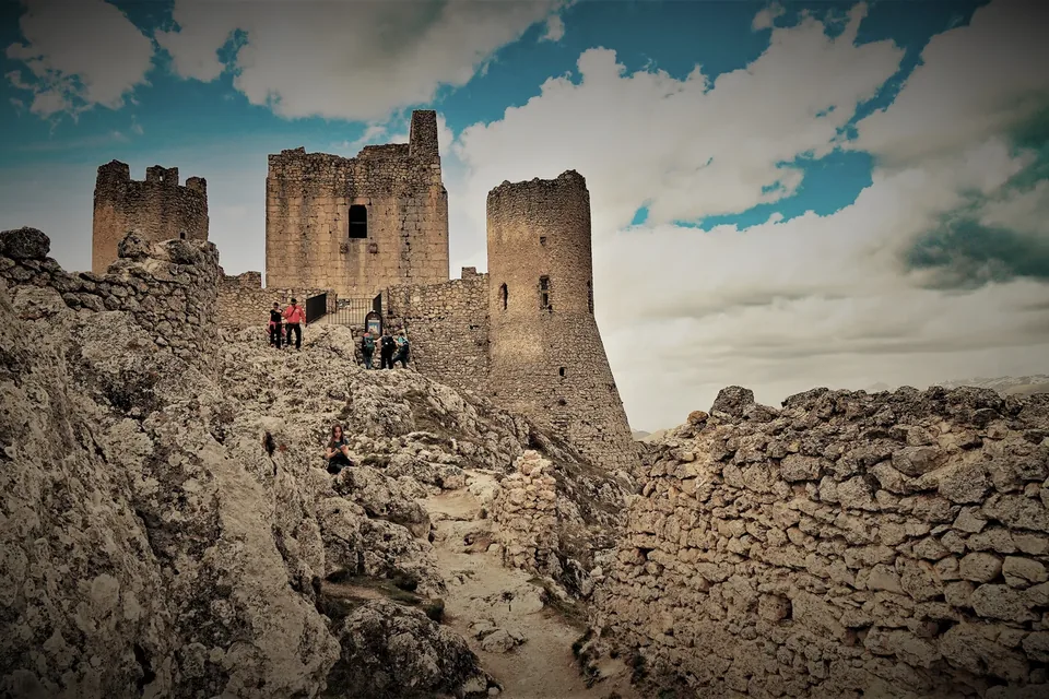
On the L’Aquila slopes, the villages of the old Barony of Carapelle show a landscape built by people: Santo Stefano di Sessanio, Castel del Monte, Calascio with its fortress, open fields and the terraced plots known as «scasci» wrested from the mountain. Beyond the Navelli plain lie Capestrano, linked to the discovery of the statue of the Italic warrior, and Ofena. The Pescara side has Benedictine abbeys and the villages of Corvara and Pescosansonesco; on the Teramo side Castelli is a great centre of ceramics, Isola del Gran Sasso has the sanctuary of San Gabriele dell’Addolorata, Civitella del Tronto its Bourbon fortress and Campli the Italic necropolis of Campovalano. Pietracamela, below Corno Piccolo, is the home of Gran Sasso mountaineering.
The Authority has created a network of themed museums: the Antiquarium in the underground rooms of its Assergi headquarters, with finds from the Palaeolithic to the Bronze Age; the Chamois Museum in Farindola, with a wildlife enclosure of about four hectares near the Vitello d’Oro waterfall; the Wolf Museum in Arsita; the Flower Museum at San Colombo di Barisciano, next to the Apennine Floristic Research Centre and its herbarium of 65,000 specimens; the Water Centre at San Pietro di Isola del Gran Sasso, with a woodland trail for blind visitors; and the Mountaineering Museum at Prati di Tivo.
Sources: Parco Nazionale del Gran Sasso e Monti della Laga — L’altopiano di Campo Imperatore · Parco Nazionale del Gran Sasso e Monti della Laga — Brochure istituzionale (PDF) · Parco Nazionale del Gran Sasso e Monti della Laga — Antiquarium di Assergi · Parco Nazionale del Gran Sasso e Monti della Laga — Museo del Camoscio · Parco Nazionale del Gran Sasso e Monti della Laga — Museo del Lupo · Parco Nazionale del Gran Sasso e Monti della Laga — Museo del Fiore · Parco Nazionale del Gran Sasso e Monti della Laga — Centro Ricerche Floristiche dell’Appennino · Parco Nazionale del Gran Sasso e Monti della Laga — Museo Centro per le Acque del Gran Sasso · Parco Nazionale del Gran Sasso e Monti della Laga — Museo dell’Alpinismo
Food and wine
The park’s cooking comes from mountain farming and shepherding, and the Authority describes it district by district in its food itineraries. In Terre della Baronia, saffron grown on the nearby Navelli plain flavours the sauces of handmade gnocchi and ravioli, almonds go into sweets such as the «pasticcio degli dei» soaked in saffron liqueur, and the lentil of Santo Stefano di Sessanio becomes a well-known soup. The same area gives canestrato of Castel del Monte, the pecorino of transhumance, grass pea, celebrated with a festival at Castelvecchio Calvisio, the turchesa potato and marcetto, a spicy spreadable cheese.
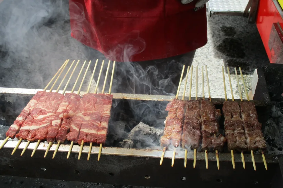
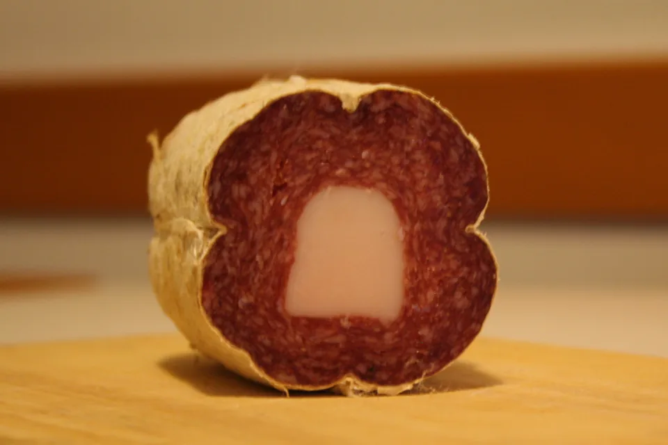
Along the Strada Maestra you can taste Campotosto mortadella, made at 1,300 metres, Laga ventricina, spicy and rich, spread on warm bread made from solina wheat, pecora alla callara, the mutton stew of transhumant shepherds, whitefish from Lake Campotosto, porcini from the Laga woods, Cortino pecorino and sweets such as ferratelle, bocconotti, almond biscuits and sweet pizza. In the Alte Vette district people still sow rye, two-row barley and solina wheat, old pulses such as cicerchiola, robiglio and vetch survive, and Paganica grows its «a pane» and «a olio» beans.
The park’s basket of products also includes L’Aquila saffron, Laga chestnuts and spelt, meat, cheese and honey. The Authority’s institutional brochure lists four Slow Food Presidia: Farindola pecorino, Castel del Monte canestrato, the Santo Stefano di Sessanio lentil and Campotosto mortadella. Products authorised to use the park mark carry a code next to the logo that identifies the producer, the product and the year of the licence, which can be checked on the Authority’s website. Apulica’s pages on the products of this area are linked to this page.
Sources: Parco Nazionale del Gran Sasso e Monti della Laga — Gastronomia, itinerari del gusto · Parco Nazionale del Gran Sasso e Monti della Laga — Itinerario del gusto nelle Terre della Baronia · Parco Nazionale del Gran Sasso e Monti della Laga — Itinerario del gusto nella Strada Maestra · Parco Nazionale del Gran Sasso e Monti della Laga — Itinerario del gusto nel distretto delle Alte Vette · Parco Nazionale del Gran Sasso e Monti della Laga — Il paniere dei prodotti del Parco · Parco Nazionale del Gran Sasso e Monti della Laga — Brochure istituzionale (PDF)
Things to do
The park is best discovered on foot. The Authority points to hundreds of marked trails built with the Italian Alpine Club: panoramic strolls, foothill walks between villages and olive groves, themed routes to hermitages, water mills, waterfalls, springs, castles and necropolises, and long routes such as the Ippovia del Gran Sasso bridle trail and the Sentiero Italia CAI. The high-mountain paths towards Corno Grande, Monte Gorzano and the main summits are safe only in summer.
The Sentiero Italia route sheets published by the Authority give a sense of the traverses. The stage from Santo Stefano di Sessanio to the Duca degli Abruzzi refuge, below Corno Grande, is 18.6 kilometres long, with 1,236 metres of ascent and 126 of descent. The next one drops from the refuge to Pietracamela in 12.7 kilometres, with 121 metres of ascent and 1,424 of descent, by way of the Monte Aquila saddle and the Garibaldi refuge, in the valley between Corno Grande and Pizzo d’Intermesoli. On Monti della Laga, the stage from Cesacastina to Padula covers 11.4 kilometres, with 482 metres of ascent and 643 of descent, towards the river Tordino.
At Prati di Tivo, below Corno Piccolo, the park offers activities on foot, on horseback and by mountain bike, and for more than sixty years the faces of Corno Grande, Corno Piccolo and Pizzo d’Intermesoli have been the training ground of Pietracamela’s climbers. The park’s wildlife includes Apennine chamois, red deer, roe deer, wolf, golden eagle and, high up, the snowfinch and the red-billed chough.
The Authority makes clear that it neither owns nor manages the trail network: before a walk it asks visitors to check the route with the municipality concerned, with the CAI or with the association of mountain guides, and to set out prepared, with suitable equipment and, where needed, a professional guide.
Sources: Parco Nazionale del Gran Sasso e Monti della Laga — Itinerari a piedi · Parco Nazionale del Gran Sasso e Monti della Laga — Sentiero Italia CAI, Santo Stefano di Sessanio – Rifugio Duca degli Abruzzi · Parco Nazionale del Gran Sasso e Monti della Laga — Sentiero Italia CAI, Rifugio Duca degli Abruzzi – Pietracamela · Parco Nazionale del Gran Sasso e Monti della Laga — Sentiero Italia CAI, Cesacastina – Padula · Parco Nazionale del Gran Sasso e Monti della Laga — Museo dell’Alpinismo · Parco Nazionale del Gran Sasso e Monti della Laga — Fauna
When to go
The park can be visited all year, but the season changes a great deal with altitude. Summer is the time for the high-mountain paths, the only months the Authority considers them safe, and the season of summer grazing, when flocks and herds climb to the pastures of Campo Imperatore. The plateau has a continental climate: cool in summer, cold in winter, almost arid on the mounds and ridges.
Spring and autumn suit many routes at middle and low altitude. In spring the yellow pheasant’s eye, a species long thought extinct, flowers on the slopes of Gran Sasso at its only site in Italy. In autumn the roaring of red deer echoes through the Laga woods, Lake Campotosto fills with thousands of waterbirds and the woods yield porcini and chestnuts.
In winter snow transforms the park: some routes remain possible but call for crampons or skis and suitable experience, and conditions need checking day by day. Guided walks and events listed by the Authority appear in the «Oggi nel Parco» section of its website, with the date and place of each one.
Sources: Parco Nazionale del Gran Sasso e Monti della Laga — Itinerari a piedi · Parco Nazionale del Gran Sasso e Monti della Laga — L’altopiano di Campo Imperatore · Parco Nazionale del Gran Sasso e Monti della Laga — Flora e vegetazione · Parco Nazionale del Gran Sasso e Monti della Laga — Fauna · Parco Nazionale del Gran Sasso e Monti della Laga — Brochure istituzionale (PDF) · Parco Nazionale del Gran Sasso e Monti della Laga — Itinerario del gusto nella Strada Maestra · Parco Nazionale del Gran Sasso e Monti della Laga — Oggi nel Parco, archivio degli eventi
Getting there and around
By car from Rome you take the A24 motorway: the Assergi exit leads to the L’Aquila side, the Colledara/San Gabriele exit to the Teramo side; for the Pescara side you take the A25 Rome–Pescara to the Castiglione a Casauria exit. From the Adriatic coast, on the A14, you leave at San Benedetto del Tronto and follow the Salaria for the Ascoli Piceno side, at Giulianova/Teramo and then the SS80 for the Teramo side, and at Pescara Nord towards Penne and Farindola for the Pescara side. Fonte Cerreto, three kilometres from the Assergi exit, is the lower station of the Gran Sasso cable car.
By train you reach Teramo on the Pescara–Giulianova–Teramo line or Pescara on the Rome–Pescara line, and continue by bus. From Rome, TUA coaches run to L’Aquila, Teramo and Pescara and START coaches to Ascoli Piceno. According to the Authority every municipality in the park is served by regional buses leaving from the provincial capitals: TUA in Abruzzo, START in Marche and COTRAL in Lazio. The airports it lists are Abruzzo Airport in Pescara and Rome’s Fiumicino and Ciampino.
The park is large and its sides lie far apart: it is better to choose one sector and one village as a base rather than move from valley to valley every day. Travellers using public transport should check the day’s services and return journeys in advance, above all to reach the starting points of walks.
Sources: Parco Nazionale del Gran Sasso e Monti della Laga — Come raggiungere il Parco · Parco Nazionale del Gran Sasso e Monti della Laga — Centro visita e show room dei prodotti tipici di Fonte Cerreto
Where to stay
The Authority’s map shows accommodation, campsites, refuges and producers across the park, and the choice of base depends on the side. On the L’Aquila side the Barony villages, such as Santo Stefano di Sessanio, Calascio and Castel del Monte, are handy for Campo Imperatore and the farming landscapes, while Assergi and Fonte Cerreto are the gateways to Gran Sasso from the L’Aquila direction. On the Teramo side Pietracamela and Prati di Tivo sit below the faces of Corno Piccolo; Farindola is the gateway to the mountain from the Vestini side. For Monti della Laga, stay in the villages around Campotosto or between Crognaleto and Amatrice. Refuges and high-altitude lodgings are best chosen after checking services and opening with whoever runs them.
Museums and visitor centres help to understand the park, but opening should always be checked. In the Authority’s catalogue, checked on 2026-10-28, all seventeen facilities are listed as closed, including the visitor centre and local produce showroom at Fonte Cerreto; the Wolf Museum page states that it is closed for energy-efficiency works. The English page of the Flower Museum says instead that the museum can be visited by appointment and that the park’s botanical garden is open free of charge (checked on 2026-10-28); for information the Floristic Research Centre answers on +39 0862 899025.
For everything to do with a visit, the institutional point of reference is the Authority’s public relations and communication office, at the Assergi headquarters, Via del Convento 1: telephone +39 0862 6052205, email urp@gransassolagapark.it (checked on 2026-10-28).
Sources: Parco Nazionale del Gran Sasso e Monti della Laga — Mappa del Parco · Parco Nazionale del Gran Sasso e Monti della Laga — Museo del Camoscio · Parco Nazionale del Gran Sasso e Monti della Laga — Musei e centri visita · Parco Nazionale del Gran Sasso e Monti della Laga — Museo del Lupo · Parco Nazionale del Gran Sasso e Monti della Laga — The Museum of the Flower · Parco Nazionale del Gran Sasso e Monti della Laga — Centro Ricerche Floristiche dell’Appennino · Parco Nazionale del Gran Sasso e Monti della Laga — Centro visita e show room dei prodotti tipici di Fonte Cerreto · Parco Nazionale del Gran Sasso e Monti della Laga — Contatti
Nearby
L’Aquila, whose municipal territory includes Assergi and Fonte Cerreto, lets you combine the mountains with a city visit, and the page on Santo Stefano di Sessanio looks more closely at one of the Barony villages. Between the two opens the Navelli plain, where the L’Aquila saffron that flavours the cooking of the park’s villages is grown: a good reason to stop among fields and stone villages.
The Authority also looks after several Natura 2000 sites linked to the park: the upper course of the river Tirino, the Montagna dei Fiori and di Campli with the Salinello gorges, the riverside woods of the Tronto, and Monti della Laga with Lake Campotosto. On the Lazio side the Authority’s brochure names the Lago Negro wetland among the natural gems of the protected area, in a landscape of sandstone farmhouses and wayside chapels; on the Marche side, small villages set among centuries-old chestnut groves.
In the same region, the Abruzzo, Lazio and Molise National Park is a separate protected area with its own boundaries, visitor centres and rules: the two parks can be combined in a longer journey through the mountains of Abruzzo, giving each its own time.
Sources: Parco Nazionale del Gran Sasso e Monti della Laga — Antiquarium di Assergi · Parco Nazionale del Gran Sasso e Monti della Laga — Centro visita e show room dei prodotti tipici di Fonte Cerreto · Parco Nazionale del Gran Sasso e Monti della Laga — Itinerario del gusto nelle Terre della Baronia · Parco Nazionale del Gran Sasso e Monti della Laga — Brochure istituzionale (PDF) · Parco Nazionale del Gran Sasso e Monti della Laga — Mappa del Parco · Parco Nazionale del Gran Sasso e Monti della Laga — La storia del Parco
The managing body

Gran Sasso and Monti della Laga National Park Authority
Official website
Established in 1995, the Park Authority manages a protected area of about 150,000 hectares in 44 municipalities of Abruzzo, Lazio and Marche. It is based at Assergi, in the former Franciscan convent, with further centres at Farindola, Isola del Gran Sasso and Amatrice; it looks after nature conservation, the plant research of the San Colombo centre, the network of museums and visitor centres and the park’s product mark.
For a visit the reference source is the Authority, through its institutional website, its public relations and communication office and the material it publishes, from maps to the museum guide. For trail conditions the Authority refers walkers to the municipalities, the CAI and the mountain guides.
Source: Parco Nazionale del Gran Sasso e Monti della Laga — La storia del Parco · Parco Nazionale del Gran Sasso e Monti della Laga — Il territorio · Parco Nazionale del Gran Sasso e Monti della Laga — Centro Ricerche Floristiche dell’Appennino · Parco Nazionale del Gran Sasso e Monti della Laga — Musei e centri visita · Parco Nazionale del Gran Sasso e Monti della Laga — Il paniere dei prodotti del Parco · Parco Nazionale del Gran Sasso e Monti della Laga — Contatti · Parco Nazionale del Gran Sasso e Monti della Laga — Itinerari a piedi · Parco Nazionale del Gran Sasso e Monti della Laga — Download, materiale informativo
Local tourist information
Local tourist offices help with opening times, events and transport on the day.
- Ufficio relazioni con il pubblico e comunicazione (Ente Parco Nazionale del Gran Sasso e Monti della Laga) · Via del Convento 1, 67100 Assergi (AQ) · +39 0862 6052205 · urp@gransassolagapark.it · Official website
Source: Parco Nazionale del Gran Sasso e Monti della Laga — Contatti · checked on
YOUR JOURNEY
How to shape a journey here
Four days on one side of the park: Campo Imperatore and the Barony villages, a trail chosen with local guides and the food of transhumance. Museums, lodgings and guides to be confirmed with local operators and the Park Authority.
Plan your trip